
South Brookline contains some of the town’s most impressive open spaces.
It also contains some of its most challenging roads.
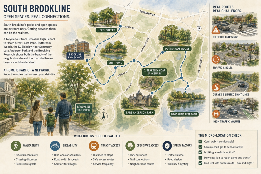
A June bicycle tour described in Brookline Town Meeting member correspondence connected Brookline High School with Heath Street, Lost Pond, Putterham Woods, the D. Blakeley Hoar Sanctuary, Larz Anderson Park and the Brookline Reservoir. The route became a moving lesson in both neighborhood assets and roadway risk.
That is a useful frame for buyers.
A home is not only its interior, lot and school assignment. It is also the network someone must use to walk a child to school, reach a park, ride to transit or cross a major road.
South Brookline’s open-space network is larger than many buyers realize
Much of Brookline’s public image is built around Beacon Street, Coolidge Corner and the Green Line. South Brookline offers a different landscape.
The Town describes the D. Blakeley Hoar Sanctuary as approximately 25 acres of undeveloped land behind Baker School, with wetlands, vernal-pool habitat, a stream, puddingstone outcrops and a loop trail. Lost Pond connects to additional conservation land in Newton. Putterham Woods has been established and opened at the municipal golf course. Larz Anderson Park is Brookline’s largest park at more than 60 acres, and the Reservoir provides one of the town’s most recognizable walking loops.
Together, these places create a remarkable chain of parks, woods and sanctuaries.
But a map showing nearby green space does not tell a buyer how easy or safe it is to reach.
Access quality is part of location quality
The June ride crossed Route 9, moved through major intersections and traffic circles, and used Lee Street near the Reservoir. Those transitions are where a recreational amenity becomes a transportation question.
Brookline’s official Vision Zero page reports more than 1,800 crashes on town streets from 2019 through 2023, with more than 350 people injured and three killed. The Town’s adopted approach starts from the position that deaths and serious injuries are preventable and that street design should account for inevitable human error.
Related reading: Vision Zero Brookline: Big Promise, Hard Math, and What It Means for Daily Life (and Real Estate)
For a buyer, that means proximity should not be measured only in feet or minutes.
A park that is a quarter mile away may feel distant if the route requires an uncomfortable crossing. A school that looks walkable on a listing map may function differently during morning traffic. A quiet interior street may feed into a difficult intersection used several times every day.
How to test a South Brookline micro-location
Online maps are a starting point, not a conclusion. Before making an offer, test the routes that will matter to your household.
1. Walk the school route at school-travel time
Observe vehicle speeds, turning movements, crossing distances and whether drivers yield. Check the route in both directions; an easy morning crossing may become harder in the afternoon.
2. Ride or walk to the nearest park
Do not stop at the park entrance on the map. Identify where the usable entrance actually is and whether bicycles are permitted. Brookline’s nature sanctuaries are managed for passive use, and some prohibit bicycling and dogs even when a public trail is present.
3. Cross Route 9 on foot
If the household expects to use both sides of the corridor, experience the crossing directly. Note signal timing, refuge space, turning traffic and the comfort level for children or older adults.
4. Drive the route after dark and in rain
Curves, glare, lane markings and visibility can feel entirely different outside a sunny open house. Check how comfortably a driver can see pedestrians and cyclists.
5. Look beyond the front door
Notice sidewalk width and condition, curb ramps, drainage, snow-storage areas, street lighting and the sight line when exiting the driveway.
Related reading: Brookline pedestrian safety: reading a block like a local
6. Review planned transportation work
Brookline’s Vision Zero materials include high-priority network maps and crash-analysis resources. Proposed changes may improve a location, but construction timing and final funding matter.
Open space can be both an amenity and a responsibility
Homes near woods, wetlands and conservation land offer privacy, views and access to nature. They can also require more careful due diligence.
Buyers should consider:
- drainage and groundwater conditions;
- conservation or wetland buffers;
- mature-tree maintenance;
- insects, wildlife and seasonal vegetation;
- rules for sanctuary use;
- visibility changes when leaves fall; and
- whether the public entrance is near the property or on the opposite side of the open space.
The goal is not to turn natural space into a risk list. It is to understand the property as part of an ecosystem rather than as an isolated lot.
What sellers can communicate more clearly
South Brookline sellers often know practical details that a map cannot show.
A strong listing presentation can explain the actual walking route to Baker School, the nearest sanctuary entrance, where residents access Larz Anderson Park, or which route avoids a difficult crossing. That information should be factual and should not minimize known traffic or access constraints.
The most persuasive neighborhood story is the one a buyer can verify.
The planning lesson for Brookline
The bicycle tour linked historic sites, housing, parks and sanctuaries that many residents rarely experience together. Its larger lesson is that Brookline already has valuable destinations. The challenge is connecting them safely.
Vision Zero, intersection design, sidewalk quality and bicycle access are not separate from parks and housing. They determine who can use those assets independently and how much of the town feels genuinely connected.
For real estate, that connectivity is part of long-term neighborhood quality.
The bottom line
South Brookline rewards a closer look.
Its woods, parks, schools and historic landscape can be extraordinary. Its major roads and complex intersections require equally serious attention.
Buyers should evaluate the neighborhood the way they expect to live in it: on foot, by bicycle, by car and at the times of day that matter. The best micro-location is not simply close to an amenity. It provides a route people will actually feel comfortable using.
Related reading: Brookline’s Route 9 Redevelopment Vote Is Really a Tax, Housing, and Land-Use Test
Primary sources